Category Archives: Uncategorized

New book chapter: The Research Handbook on Digital Data is published!

We are delighted to be part of the Research Handbook on Digital Data: Interdisciplinary Perspectives, a new volume bringing together scholars from a wide range of fields to investigate digital data and its growing role in contemporary life. The book delves into the role and consequences of digital data across multiple dimensions of organisational and social life.  

Spanning 408 pages, 24 chapters, and 56 contributors, this Research Handbook surveys critical scholarship across several disciplines, from management and sociology to economics and geography, building a solid conceptual foundation for understanding the growing significance of digital data in today’s world.  

The book is organised into six sections: an introduction, followed by Data Foundations, Data Design, Data in Practice, Data Governance, and Data Use, and closing with an afterword. Our contribution sits within Section 5 of the book, dedicated to Data Use. This section examines how the digital turn and data-driven systems are reshaping the way different domains are organised, managed or governed, as well as the practices implemented within them, and how this continues to evolve with emerging developments such as synthetic data or distributed machine learning. The chapters collectively raise and tackle both new and longstanding issues that demand social, political, regulatory and legal responses, around questions of privacy, ethics, data droughts and deluge, hallucinations and more.  

Our chapter “The nature and development of a planning data ecosystem” is accessible in our open access archive [here]. It examines the nature and development of data ecosystems through a comprehensive case study of Ireland’s planning development and control data ecosystems from 2000-2024. Using assemblage theory as a theoretical framework, we conceptualise data ecosystems as assemblages of data assemblages — complex socio-technical arrangements that evolve through non-linear, contingent processes. The Irish planning system demonstrates how data ecosystems develop through “jerry-rigging” over time, involving 31 local authorities, national agencies, and various digital platforms that create both functional workflows and significant data frictions. The research employs qualitative methodology including stakeholder interviews, system mapping, and data flow analysis to reveal how technical incompatibilities, organisational cultures, and resource constraints impede data mobility across the ecosystem. Despite operational challenges, the system functions through adaptation and ongoing reform initiatives. The study contributes to understanding data ecosystems as emergent, palimpsestic socio-technical configurations requiring further empirical and theoretical investigation across sectors and domains. 

The book was launched on April 1 by its editors Aleski Aatonen (Stevens Institute of Technology), Marta Stelmaszak (Isenberg School of Management, University of Massachusetts Amherst) and Kalle Lyytinen (Case Western Reserve University).  During the launch, Rob Kitchin presented the section on Data Use where our chapter appears. The launch drew 138 live participants, and you can (re)watch the recording [here].   

It took almost exactly two years from the initial idea to the publication, and the Data Stories team is glad to be part of it!  

—————– 

Book chapter reference: Davret, J., Kayanan, C. M., Kitchin, R., & Mutter, S. (2026). The nature and development of a planning data ecosystem. In A. Aaltonen, M. Stelmaszak, & K. Lyytinen (Eds.), Research Handbook on Digital Data (pp. 324–342). Edward Elgar Publishing. https://doi.org/10.4337/9781035348718.00032

Want to share this? (click + below for more options)

Digital Planning in Zurich and Playing the Housing Market at BeNeLux Geography 2026

It’s the Spring teaching term, which means Carla has been busy with curriculum development, teaching and assessment. Regardless, Carla has managed to participate in two Data Stories relevant events, collecting a quirky pair of BeNeLux designed conference socks and a dinner in a charming fondue chalet overlooking the Zurich mountains! 

Land-Use Planning in the Digital Age: Processes, Impacts and Opportunities 

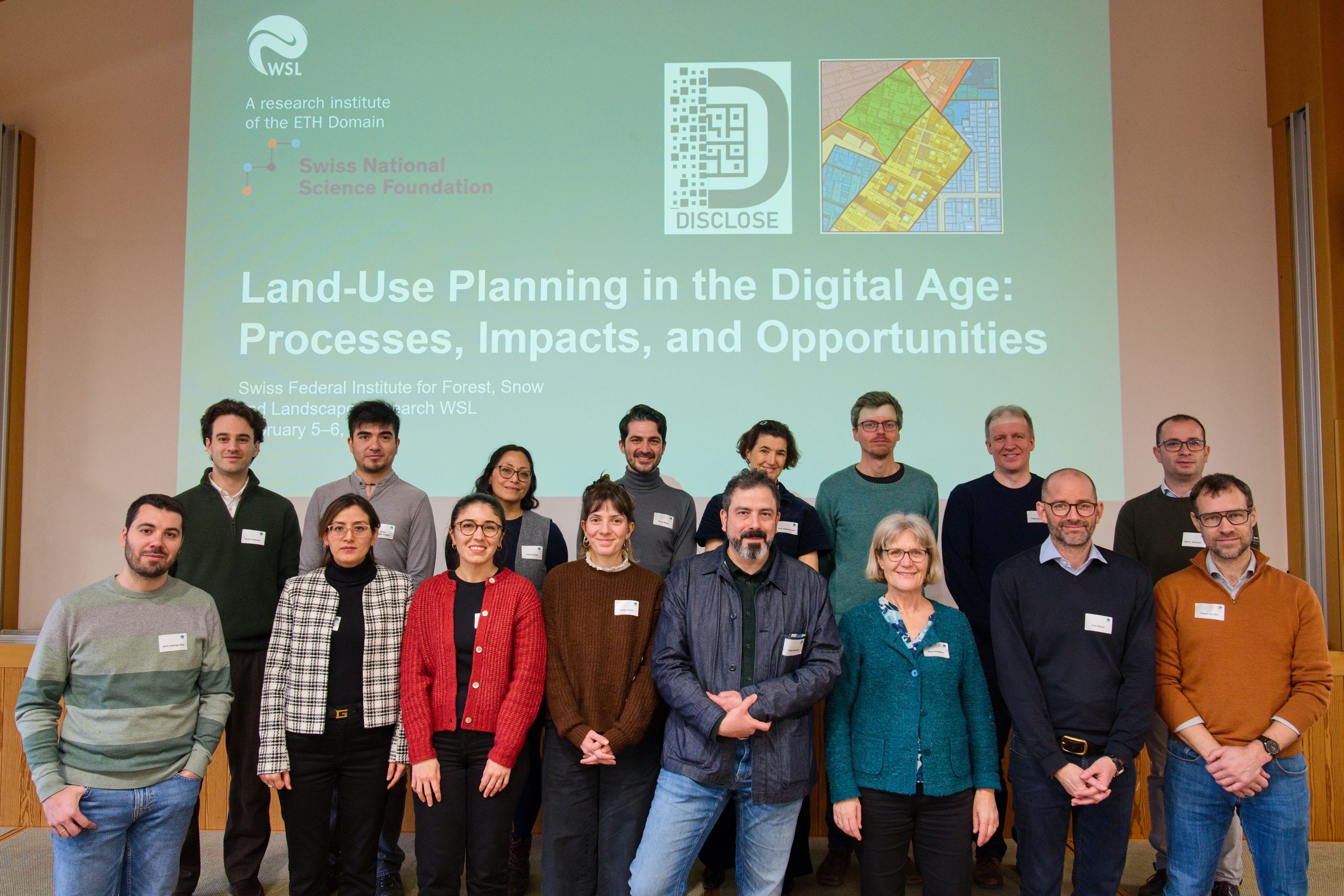
On 5-6 February, Carla was invited to attend the workshop, Land-Use Planning in the Digital Age: Processes, Impacts and Opportunities. The workshop was hosted by the SILAR and DISCLOSE project teams, both headed by Principal Investigator Prof. h.c. Dr. Anna Hersperger and held in the Swiss Federal Research Institute (WSL). 

Held over two days, the workshop included a series of presentations by the project team and by invited speakers representing both academia and the planning practice. Two central questions the project team were investigating were: 1) How does digitalisation reshape processes and practices? And 2) What are the promises and pitfalls of digitalisation in land-use planning? Both of these questions were underpinned by concerns around how research findings could make an impact for practice.  

What made this workshop stand out was its focus on methods to extract high level insights from all the participants. In addition to the standard format of speaker presentation followed by Q&A, Hersperger’s team incorporated activities such as short free writing sessions to stimulate discussion, round table discussions based on specific prompts, group work to determine gaps in our knowledge and fixed research questions for future research agendas. For example, the two central questions from above were whiteboarded in small groups. Each group considered answers to the questions and provided suggestions on theoretical gaps that remain unexplored and unanswered. Or for another example, the team created placemats for use during the lunch break and these mats had provocative comments such as: 

“Land-use planning in the digital age means modelling the future with GIS, big data, and algorithms—only to be surprised that humans still don’t behave like the model.” 

“Digital land-use planning: when the algorithm knows where everything should go, but not why no one wants it there.” 

Another stand out was the deliberate attempt to bring together researchers and practitioners from varying European countries. These types of workshops demonstrate how the academy has expanded in its effort to interject research into practice. Importantly, the work showcased demonstrated the innovative work happening in the WSL on the digitalisation of planning and the ongoing efforts to theorise how digitalisation is concretely impacting the planning profession. Many questions were raised and left unanswered—and indicator of the challenges the planning profession will grapple with in the transition to full digitalisation. 

Ultimately, the project team aims to co-produce a co-authored essay based on the workshop with all the involved participants; a large feat but a further example of how the project team worked to think outside the box and to create an outstanding, though provoking conference. 

BeNeLux Conference 

From 8 – 10 April, Carla attended the inaugural BeNeLux conference, held at KU Leuven’s campus in Belgium. Welcoming the audience on the first day, Ate Poorthuis explained that the origin story of BeNeLux is rooted in the desire for regional colleagues to network with each other without having to travel long distances or fly. This first inaugural conference drew over 530 registered participants, representing 27 countries and over 200 institutions. For Ireland, we had three nameless and unfindable registered participants, including Carla! 

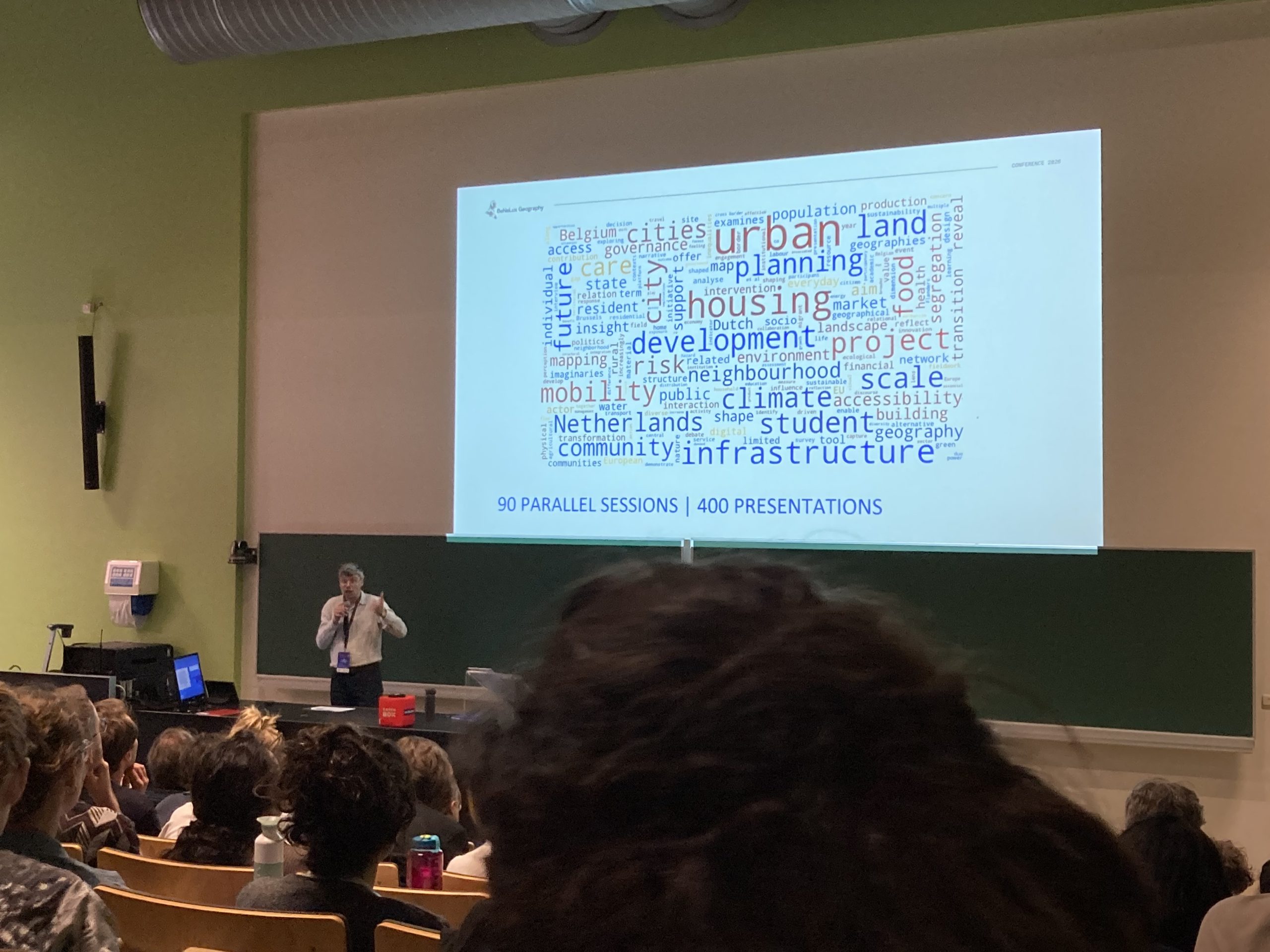
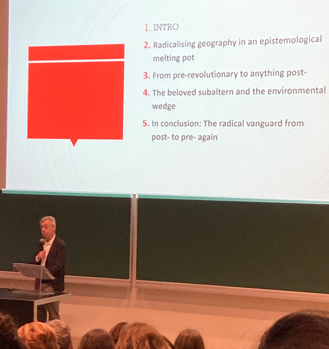
The programme for the conference included 90 parallel sessions, 400 presentations and, based on the many sessions attended, a healthy representation of Geography’s many sub-disciplines. Erik Swyngedouw, issuing the inaugural keynote address, provided a sweeping history of human geography, in a presentation aptly titled, Meandering Across Time and Space: A Geographical Expedition Through a Reactionary Discipline. What Swyngedouw covered was profound and too challenging to summarise in this blog post, but in his response to the prompt on the role of Geography in the past, present and future, Swyngedouw pointedly called out the need to break from intellectual dishonesty, to recognise that we are the architects of populist discourse and that we need to  name key mechanisms of struggle and speak truth to them. Importantly, he claimed, we need to specify our geographical desire and mobilise our intellect towards it, speaking truth to power in the process. 

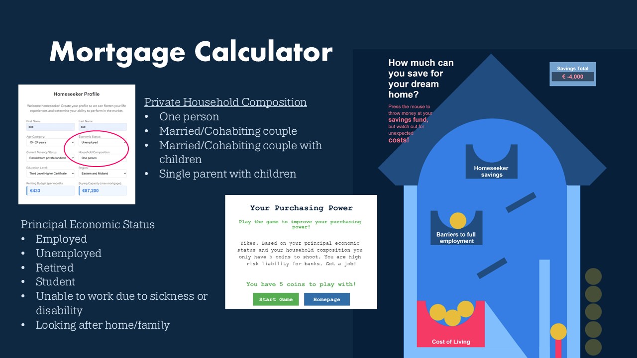
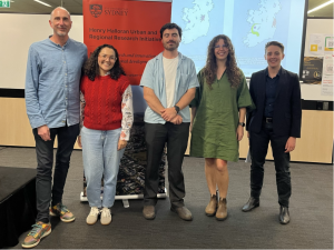
Our Commodity Narrative’s paper, Playing the Housing Market:  Creatively exploring housing commodification through a gamified spoof property website was scheduled for the second day of the conference. It was one of five papers the session co-organised by Bettina Van Hoven and Julia Munuera Garcia from University of Groningen in a special session titled Gamefying Geography: Play, Participation, and Pedagogy in the Geographical Curriculum. Though the session was designed to focus on the role of games to teach concepts in Geography, our Commodity Narratives work appealed to the organisers because of their long-standing interests in the use of arts-based methods and creative approaches to research. 

The greatest benefit of presenting the work were the questions from the audience that forced deep reflection on the Unreal Homes spoof property website we have produced: How does one win? What is the role of fun? What type of affective responses are you seeking from the users? These questions are critical to learn how to best define and describe our process on this case study, and to consider our individual and collective aims and objectives as we reach the final stages of finalising our satirical website Unreal Homes. Presenting the work and fielding questions has already led to provocative discussions amongst the team members. It was also rewarding to see Unreal Homes gleefully received from the conference attendees (one even remarked that the mortgage calculator was genius) and that even without access to the site to play it, the presentation of the satirical content and games alone elicited laughs from the audience.

Want to share this? (click + below for more options)

12 month postdoc post

Come and join the Data Stories team. We are seeking a postdoctoral researcher to work on the ‘Data Stories: Telling Stories About and With Planning and Property Data’ project.

Details about the post: https://my.corehr.com/pls/nuimrecruit/apply?id=040543

The postdoctoral researcher will undertake a comprehensive data audit of the data terrain of housing, property and planning in Northern Ireland, conduct interviews with key stakeholders with respect to selected aspects of this terrain, and compare the findings to a data audit and interviews already undertaken in the Republic of Ireland. For selected topics, such as the planning and development pipeline, a data audit and comparison will be undertaken with respect two additional countries. The successful candidate will have experience of sourcing and handling administrative datasets, be able to compile a data directory, compare datasets and evaluate data quality, and be able to conduct interviews and analyse the transcripts. They will have domain knowledge relating to Human Geography, Urban Studies, Planning, GIScience, Critical Data Studies, or related disciplines.

The posts will be for 12 months, with an anticipated commencement of 1st July 2026.

Salary
Post-Doctoral Researcher (2026): €46,805 – €53,391 p.a.(6 points)
Or Senior Post-Doctoral Researcher (2026): €54,851 – €59,655 p.a. (4 points)

Closing Date:
23:30hrs (local Irish time) on Tuesday 31st March 2026.

Want to share this? (click + below for more options)

Call For Papers (2/2): Arts-based and experimental methods in geographical investigation, CIG 2026

This year’s Conference of Irish Geographers will be hosted by University College Cork, Department of Geography with the theme ‘Connected Environments: Integration and Resilience’, on the 6th – 8th May 2026: https://www.conferenceofirishgeographers.ie 

The DataStories team is organising a session entitled: Arts-based and experimental methods in geographical investigation 

Within academia there has been an increase in and acceptance of projects that propose using arts-based and experimental methods to respond to global challenges that require reimagining, reinventing and reorganising approaches to research. In this session we seek to uncover the diverse forms of arts-based and experimental methods used in geographical investigation. We are looking for researchers who are currently engaged in research projects that adopt creative methods. Collectively, we aim to theorise the transformative potential of such methodologies for addressing pressing social, economic and environmental concerns. Beyond considering the benefits of creative methodologies, we are also interested in comprehending the challenges which emerge when incorporating creative methods into research inquiry and the ways we might mitigate or soften possible obstacles to such engagements. 

We invite discussions on the use of arts-based and experimental methods including, but not limited to: 

  • The new and hybrid methods emerging in geography (and cognate disciplines)
  • How different cultural and geographical contexts influence selected methods
  • How specifically arts-based and experimental methods generate new ways of seeing,  understanding and acting
  • Limitations and challenges of using arts-based and experimental methods
  • How creative methods can be used to co-create with stakeholders outside of the discipline and sector
  • Misuse of and ethics around arts-based and experimental methods 

Session organisers: Juliette Davret, Oliver Dawkins, Carla Maria Kayanan, Rob Kitchin and Samuel Mutter
Maynooth University Social Sciences Institute/Department of Geography, Maynooth University 

Please submit abstracts (no more than 250 words) for this special session to Carla Maria Kayanan (carla.kayanan@mu.ie) by 15 March. We will alert you on the outcome of your abstract by 20 March to give you sufficient time to upload your abstract to the CIG portal before it closes on 27 March. 

For a copy of the CFP flyer for this session, click here: PDF

To view the other session we are organising, click here: Call For Papers (1/2): Geographers in the policy arena: Building bridges between academia and evidence-based policymaking, CIG 2026

Want to share this? (click + below for more options)

Call For Papers (1/2): Geographers in the policy arena: Building bridges between academia and evidence-based policymaking, CIG 2026

This year’s Conference of Irish Geographers will be hosted by University College Cork, Department of Geography with the theme ‘Connected Environments: Integration and Resilience’, on the 6th – 8th May 2026: https://www.conferenceofirishgeographers.ie 

The DataStories team is organising a session entitled: Geographers in the policy arena: Building bridges between academia and evidence-based policymaking 

Geographic knowledge is essential for addressing contemporary policy challenges, from climate adaptation and spatial justice to urban resilience and resource management. Yet, significant gaps often exist between the production of geographic research and its effective uptake in policy processes. This session examines how geographers navigate the complex landscape of evidence-based decision-making and explores strategies for strengthening the science-policy interface.  

We invite contributions that critically examine the relationship between policymaking (in both public and private sectors) and the use of geographical knowledge. Of particular interest are perspectives that interrogate power dynamics in knowledge production and the politics of “evidence” itself.  

Topics may include, but are not limited to:  

  • institutional barriers and facilitators to evidence uptake in policymaking
  • increased role of consultants in policymaking
  • the evolution of GIS from data visualisation tools to strategic policy design instruments
  • challenges around what does and does not qualify as evidence for policymaking
  • participatory approaches to geographic knowledge production
  • the use of emerging technologies (e.g. AI-enhanced spatial analytics) in reshaping the evidence base available to policymakers.  

This session aims to share lessons learned from geographers working at the science-policy interface and to build practical frameworks for research-to-policy translation.  

Session organisers: Juliette Davret, Oliver Dawkins, Carla Maria Kayanan, Rob Kitchin and Samuel Mutter
Maynooth University Social Sciences Institute/Department of Geography, Maynooth University  

Please submit abstracts (no more than 250 words) for this session to Juliette Davret (juliette.davret@mu.ie) by 15 March. We will alert you on the outcome of your abstract by 20 March to give you sufficient time to upload your abstract to the CIG portal before it closes on 27th March. 

For a copy of the CFP flyer, click here: PDF

To view the other session we are organising, click here: Call For Papers (2/2): Arts-based and experimental methods in geographical investigation, CIG 2026

Want to share this? (click + below for more options)

Workshop Overview: Boundary Concept in the Age of Datafication

On February 19 and 20, 2026, Juliette Davret participated in a workshop on Boundaries & boundary concepts in/as datafication organised by Yana Boeva, Louis Ravn and Sarah Davies at the University of Amsterdam. This workshop explored how boundary concepts, particularly boundary objects and boundary infrastructures from Science and Technology Studies (STS), need to be reconceptualised in the age of datafication.  

The workshop brought together researchers to examine how the concepts of boundary work, infrastructure and objects are being transformed by contemporary datafication processes. The gathering created space for sustained engagement with both theoretical frameworks and empirical case studies that illuminate these transformations.  

The workshop unfolded across multiple thematic sessions over two days. The first session, titled “Boundaries, Environment and the Urban”, featured two presentations grounded in case studies of digital tools deployed in urban contexts. These presentations examined how digital technologies reconfigure urban governance and spatial boundaries.    

The second session turned attention to “Boundary Concepts, Professional & Science Practice, AI”, presenting three papers that investigated how AI, synthetic data and datafication reshape professional knowledge practices and scientific boundary work. This session examined the changing nature of expertise and authority in data-intensive environments.  

The third session of the opening day focused on “Boundary Work and the State”, featuring two presentations that explored how state institutions mobilise and are transformed by boundary-making practices in datafied governance contexts.  

The second day opened with a session on “Borders and Identities”, which included three presentations. Among these, Juliette presented her research on data intermediaries and the reconstruct ion of boundaries through labour, territorial and epistemic reconfigurations. Her case study examined planning data flows in Ireland, demonstrating how data intermediaries actively reshape the boundaries between different domains of governance and knowledge.  

The workshop concluded with a final session on “Boundary Objects and Infrastructures” featuring three presentations that examined how boundary objects scale up into infrastructures and what analytical and political implications follow from this transformation.  

Throughout the two days, the workshop structure allowed extensive time for engaging with each paper presented, as well as for collective theoretical reflection on boundary concepts. The workshop participants identified the need to collectively determine which aspects of boundary concepts in datafication contexts warrant further development.

Want to share this? (click + below for more options)

New paper: The temporal organisation and practices of planning work

The project has a new paper published in Studi Organizzativi. 

Kitchin, R., Davret, J., Kayanan, C.M. and Mutter, S. (2025) The temporal organisation and practices of planning work: The temporalities of digital infrastructure, the digital infrastructuring of temporality. Studi Organizzativi 2(2025): 180-204.

An open-access, post-print version is available on MURAL

Abstract

Digitalisation is having a profound impact on the relationship between time and planning. The temporalities of planning’s bureaucratic infrastructure is being transformed through its digitalisation, introducing machine and network time and reshaping the relations between past, present and future. In turn, the temporalities of digital infrastructure has led to re-infrastructuring of planning’s temporalities, introducing a new timescape wherein the pace, tempo, timings, time patterns and temporal modalities of planning practice have been reconfigured. Yet, despite the profound effect of digitalisation on temporal relations, clock time remains important in the organisation and work of planning given the centrality of time rules and timetables, and this will continue to be the case. Using a case study of the development and control function of planning in Ireland, this paper examines temporalities of planning’s digital infrastructures and the digital infrastructuring of planning’s temporalities, illustrating the ways in which the temporal organisation and practices of planning work are being re-cast.

Want to share this? (click + below for more options)

3D Printed Model of Cork City Goes Home

We’ve previously shared stories about exhibiting our 3D printed model of Dublin at the Synthetic Cities conference and Dublin’s Beta Festival of digital arts. However, for the last few years we’ve also had a 3D printed model of Cork stored in our lab. Last week the model of Cork finally went to a new home at the library at University College Cork (UCC).

Both models were originally created as part of the Building City Dashboards project. The original plan had been to display both models together for an end of project exhibition but this was prevented when the Covid-19 pandemic struck. After the pandemic we adopted the Dublin model and we’ve been seeking a home for the Cork model ever since.

Last year researcher Maedhbh Nic Lochlainn joined UCC as a lecturer in Human Geography and GIS. As a friend of the Data Stories project, Maedhbh had a good understanding of the model’s value, and this made her the perfect person to adopt and champion it. Maedhbh secured funding to have the model mounted for display by the same team at Display Contracts who prepared the Dublin installation for Data Stories.

Before Christmas I visited the Display Contracts workshop in North Dublin to see the model being prepared. Like it’s Dublin sibling, the Cork model measures 3.5 x 2 metres and covers 28sq km of the city. The key difference between the two is Cork’s hilly terrain. This makes the Cork model significantly thicker and bulkier. Despite the challenge, Display Contracts handled the job expertly.

The piece was delivered to UCC and assembled in the university library last Friday. Students and visitors will be able to explore Cork’s urban landscape in miniature there.

Want to share this? (click + below for more options)

New paper: The Politics of Counting Homelessness: The Case of Ireland

The project has a new paper published in Housing Policy Debate. 

Davret, J. (2026). The Politics of Counting Homelessness: The Case of Ireland. Housing Policy Debate, 1–24. https://doi.org/10.1080/10511482.2025.2599125 

An open-access, post-print version is available on MURAL  

Abstract  

Homelessness remains a critical social issue in Ireland, yet its true scale is systematically obscured by definitional limitations, methodological inconsistencies, and political interference in data collection. While official statistics reported 16,058 individuals relying on emergency accommodation as of July 2025 (a rise of +244% since July 2015), this figure excludes substantial populations: rough sleepers, domestic violence survivors, asylum seekers, and those experiencing hidden homelessness through enforced parental co-residence. This article examines the politics of homelessness enumeration through a critical analysis of seven data sources, policy documents spanning 2014–2025 and stakeholder interviews. The study reveals how Ireland’s measurement system exemplifies the political life of numbers. The analysis exposes five interconnected dimensions of measurement failure: fragmentation of sources and measurement approaches, methodological inconsistencies that undermine longitudinal analysis, systematic undercounting that renders substantial populations invisible, documented political manipulation and data integrity concerns, and structural barriers that impede comprehensive data collection and analysis. The findings demonstrate how apparently technical decisions about data collection and analysis become sites of political contestation. The research reveals the measurement politics in contemporary welfare states, demonstrating the need for inclusive frameworks, integrated systems, and transparent practices that prioritize social justice over administrative convenience. 


Want to share this? (click + below for more options)

New paper: The digital turn in planning and the production of ‘good enough’ planning systems

The project has a new paper published online first in European Planning Studies.

Kayanan, C., Mutter, S., Davret, J. and Kitchin, R. (2025, online first) The digital turn in planning and the production of ‘good enough’ planning systems. European Planning Studies. doi: 10.1080/09654313.2025.2599869

An open access, post-print version is available on MURAL

Abstract

The digitalization of planning has taken place in a context where planning work is on-going and cannot be halted, and in which there are embedded institutional and technical systems and practices, as well as a number of technical, regulatory and sociocultural data frictions. This context has led to a sub-optimizing approach to digitalization. In this paper, we examine the digital mediation of planning through an in-depth case study of a multiscale planning development and control data ecosystem in Ireland. We detail the incrementalist nature of the digital turn in planning and how this institutionalizes a ‘good enough’ digitalized planning system; that is, a system that is functional and performs essential tasks, but not necessarily in an optimal manner and which is always open to potential improvements. We develop a conceptual basis for assessing ‘good enough’ and
through its application contend that ‘good enough’ planning is a sufficient and reasonable state of affairs given the substantive challenges of creating and maintaining a complex data
ecosystem and that there are incremental limits to achieving ‘better planning’. As such, any technological solutionist claims promising to radically reconfigure and fix planning’s operation shortcomings, such as the introduction of artificial intelligence tools, require careful assessment.

Want to share this? (click + below for more options)